Our Region
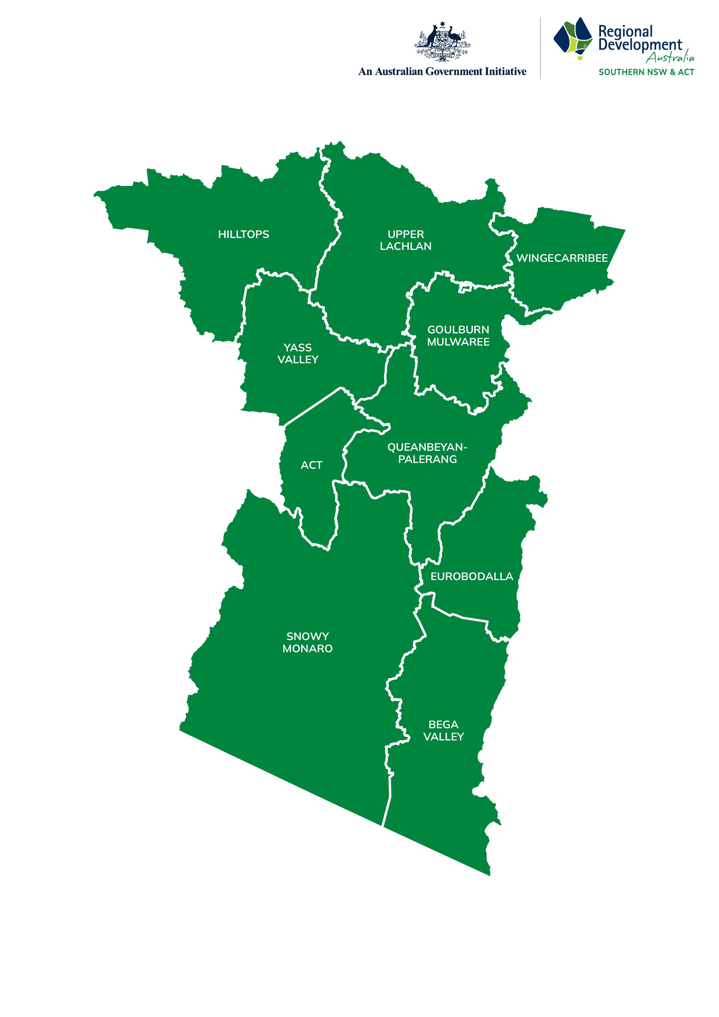
RDA Southern NSW and ACT (RDASNA) combines the regions of RDA Southern Inland, ACT and two LGAs from Far South Coast.
The region encompasses 9 NSW LGAs including:
Wingecarribee
Goulburn-Mulwaree
Upper Lachlan
Yass Valley
Hilltops
Queanbeyan-Palerang
Snowy Monaro
Eurobodalla
Bega Valley
plus the Australian Capital Territory.
This diverse region spanning from the Snowy Mountains, across the Southern Tablelands and Highlands, to the Sapphire Coast includes a land mass of over 56,000km2 with a population of over 750,000.
We are proud to represent, a region with the most spectacular topography in NSW.
The Southern NSW Region includes the following local government areas:
AUSTRALIA CAPITAL TERRITORY
The Australian Capital Territory (ACT), located in southeastern Australia, is the nation's smallest self-governing internal territory. Covering an area of approximately 2,358 square kilometers, the ACT is geographically compact yet significant, as it is home to Canberra, Australia's capital city and political heart. The ACT is landlocked, bordered entirely by New South Wales. Its central location places it within driving distance of Sydney (around 280 kilometers northeast) and Melbourne (approximately 660 kilometers southwest).
Around 70% of the ACT is preserved as national parks and nature reserves, including Namadgi National Park, which forms part of the Australian Alps and is known for its unique flora, fauna, and Aboriginal heritage sites.
While the ACT's economy is predominantly service-oriented, a few key industries define its economic activity:
Public Administration and Governance
As the seat of the Australian Government, Canberra hosts federal departments, embassies, and other governmental bodies, making public administration the largest employer in the territory. This sector significantly influences the ACT's economy and population dynamics.
Black Mountain Tower Image Credit: Kelly Kenney
Education and Research
The ACT is a hub for education and research, home to prestigious institutions such as the Australian National University (ANU) and the University of Canberra. These institutions drive innovation and research, particularly in fields such as science, technology, and public policy.
Tourism and Events
Tourism plays a vital role, with visitors drawn to cultural institutions such as the National Gallery of Australia, Parliament House, and the Australian War Memorial. The territory also hosts significant national events, such as Floriade, which celebrates spring with vibrant floral displays.
Technology and Innovation
The ACT boasts a growing technology sector, supported by initiatives encouraging startups and entrepreneurship. The Canberra Innovation Network (CBRIN) is a key player in fostering innovation in fields such as IT, defence technologies, and renewable energy.
Agriculture and Viticulture
Although agriculture is not as prominent as in surrounding New South Wales, the ACT supports niche industries such as sheep grazing, cattle farming, and viticulture. The Canberra wine region, known for its cool-climate wines, has gained international recognition for its high-quality Shiraz and Riesling.
The ACT combines natural beauty with a dynamic economy, contributing to its reputation as a liveable and progressive region. Its compact size, efficient infrastructure, and rich cultural and educational offerings make it a unique and vital part of Australia's national landscape.
The Australian Capital Territory (ACT) operates under a unique governance structure compared to other states and territories in Australia. Unlike other regions that have separate local councils or municipalities, the ACT has an integrated government system that combines state and local government responsibilities. This arrangement is due to the territory's relatively small geographical size and population.
Sapphire Coast Guiding Co., Merimbula. Image Credit: Destination NSW
Bega Valley
The Bega Valley Shire encompasses an expansive 6,040 square kilometers (2,330 sq mi) and boasts a coastline spanning 225 km (140 mi), adorned with 101 beaches and 26 estuaries. Approximately 78% of this vast territory is dedicated to national parks and state forests, preserving its natural beauty.
Its primary industry revolves around timber production, with dairy farming and other forms of agriculture also playing significant roles. Additional economic activities include fishing, oyster harvesting, and tourism.
From Bermagui in the north to the Victorian border in the south, the region encompasses several towns such as Bega, Tathra, Merimbula, Tura Beach, Wolumla, Cobargo, Bemboka, Pambula, and Pambula Beach. Notably, it features the former whaling port turned tourism hotspot and major port of Eden, adding historical and cultural richness to the area.
Main towns: Eden, Merimbula, Cobargo, Pambula
Local Council: Bega Valley Shire Council
Billy’s Beach, Narooma. Image Credit: Destination NSW
Eurobodalla
Located on the far South Coast of New South Wales, Eurobodalla is easily accessible from Sydney, approximately a four-hour drive via the picturesque Sydney to Melbourne coastal route. Canberra is also within easy reach, with a travel time of around two hours by car.
Stretching from South Durras to Tilba Tilba in the south, the Eurobodalla region offers a stunning blend of coastal vistas, rivers, forests, and agricultural lands. Explore charming seaside towns such as Batemans Bay, Broulee, Narooma, Moruya, and Central Tilba, each adorned with the refreshing embrace of the ocean.
Main towns: Batemans Bay, Broulee, Narooma, Moruya, and Central Tilba
Local Council: Eurobodalla Shire Council
Goulburn Mulwaree
Just two hours from Sydney and one hour from Canberra, Goulburn-Mulwaree gives businesses great access to markets, resources and ports but with much lower overheads. Combined with a strong and ready labour pool, you can see why many business have chosen Goulburn for their next location. Location, with country and rural lifestyle benefits, as well as excellent services and amenities, makes the Goulburn area a fantastic place to live and work.
Main town: Goulburn
Local Council: Goulburn Mulwaree Council
Business Directory: Goulburn Chamber of Commerce
Goulburn Court House, Goulburn. Image Credit: Destination NSW
Scenic Country, Hilltops Region. Image Credit: Destination NSW
Hilltops
The Hilltops region is located in the Tablelands of New South Wales. The area is just over an hour north of Canberra and features the thriving towns of Young, Harden and Boorowa, along with a wide range of villages that are bursting with a rich history. The region is renowned for agriculture, including sheep grazing, cropping, viticulture, stone fruits and horticulture. The area is located along a strategic transport corridor, including the Hume Highway, which is the busiest interstate road freight corridor in Australia, and is closely connected to major markets, including Sydney and Canberra. In fact, 60% of Australia’s population can be reached from Young within 10 hours driving time.
Main towns: Boorowa, Harden & Young
Local Council: Hilltops Council
Business Directory: Visit Hilltops Region
Queanbeyan-Palerang
Queanbeyan-Palerang is an area of approximately 5,300km2 located between the eastern border of the ACT and the Great Dividing Range. Queanbeyan makes up the majority of the urban population and is a prospering river city. The balance of the population is made up by the townships of Bungendore and Braidwood and numerous smaller rural villages and hamlets such as Araluen, Captains Flat, Bywong, Majors Creek and Wamboin.
For more than 175 years, people have been moving to Queanbeyan and the region in search of a better lifestyle.
Main towns: Queanbeyan, Bungendore and Braidwood
Local Council: Queanbeyan-Palerang Regional Council
Business Directory: Bungendore Chamber of Commerce
Queanbeyan River, Queanbeyan. Image Credit: Destination NSW
Kiandra, Kosciuszko National Park. Image Credit: Destination NSW
Snowy Monaro
With the three main population centres all on major highways, easy access to Canberra as well as Sydney, Melbourne and the coast, good services and amenities, Snowy Monaro offers unlimited potential for the astute investor.
Couple this with vibrant, cohesive communities, a stable workforce, strong economic drivers and a post card perfect natural environment, Snowy Monaro really is the place to live, work and invest.
Main towns: Jindabyne, Cooma and Bombala
Local Council: Snowy Monaro Regional Council
Business Directory: Cooma Chamber of Commerce
Crookwell Wind Farm, Crookwell. Image taken from Crookwell Drone Selects. Image Credit: Destination NSW
Upper Lachlan is an area that is known for its quaint villages, fine wool, potato production, wind farms, history and picturesque countryside. The Upper Lachlan region sits high on the Great Dividing Range in the New South Wales Southern Tablelands and is bounded by the Abercrombie, Wollondilly and Lachlan rivers. The regional centre is the township of Crookwell which is 45km west of Goulburn, about 110km north of Canberra and about 130km south-east of Bathurst. Sydney’s CBD is a picturesque 2 ½ hour drive.
Main towns: Crookwell, Collector, Gunning, Taralga
Local Council: Upper Lachlan Shire Council
Business Directory: Upper Lachlan Shire Council
Wingecarribee River, Berrima. Image Credit: Destination NSW
Wingecarribee
Perfectly located almost midway between Sydney and Canberra, Wingecarribee, also known as the Southern Highlands, is home to a vibrant and diverse community of urban, agricultural and natural environments working in harmony.
With a population of around 49,000 people and covering an area of 2,700 square kilometres, the Southern Highlands is located at or above 640 metres above sea level.
Main towns: Bowral, Mittagong and Moss Vale
Local Council: Wingecarribee Shire Council
Business Directories: The Fold Southern Highlands, Destination Southern Highlands
Yass Valley
Located on the doorstep of the Nation’s Capital, Yass Valley boasts a modern and well renowned food and wine scene, numerous education options, employment opportunities and medical and general services including a hospital, three large supermarkets, sporting facilities and housing opportunities well below the median house price of nearby Canberra.
This combined with friendly, helpful locals, stunning landscapes and natural wonderlands contribute to why Yass Valley is capturing the interest of people wanting to live, work and invest within the region.
Main towns: Yass, Murrumbateman and Binalong
Local Council: Yass Valley Council
Business Directory: Yass Chamber of Commerce
Long Rail Gully Wines, Murrumbateman. Image Credit: Destination NSW


